An IoT-based early warning system for natural occurrences is being piloted in Georgia
In Georgia, the issue of rising seismic activity has previously been addressed. An amateur group started a trial experiment to track earthquake activity. The monitoring system was initially installed in the Samtskhe-Javakheti region’s village of Sameba, which is situated in one of the seismically most active zones. There are earthquakes practically every day. The next stage will be to put an early warning system into place if we are fortunate enough to discover a correlation between the occurrences that, in theory, precede earthquakes and validate the theory.
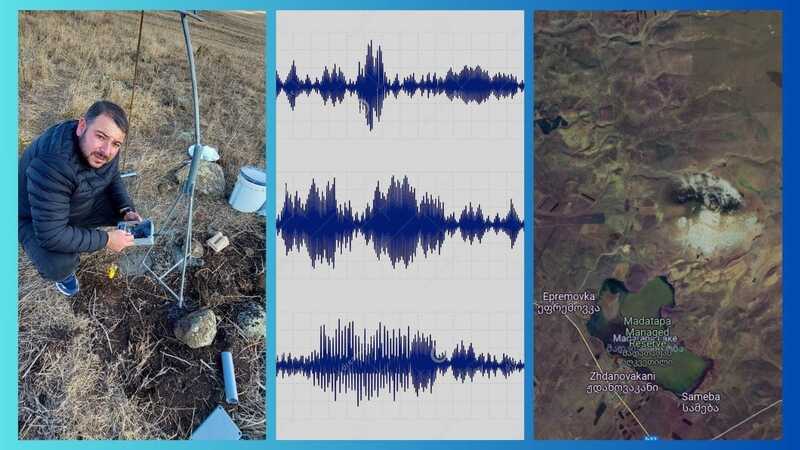
The goal is to use IoT to process and transfer scientific data. The project is being carried out in an earthquake-prone area. To gather information on a range of factors, such as changes in the concentration of argon gas in the air, monitoring of infrasound, and ground motion, a network of Internet of Things (IoT) devices must be set up.
For analysis, the information gathered by the Internet of Things devices is sent to a central server. The server looks for trends and abnormalities in the data using machine learning methods. An alert is sent to the appropriate authorities and the impacted communities in the event that an abnormality is found.
The author, IT professional and “ISOC Georgia” representative Konstantin Stalinsky, claims that the project idea’s uniqueness resides in the early warning system and monitoring network’s low cost in the potential area of natural disasters.
“The theory states that infrasound waves occur before any earthquake, no matter how small. What infrasound is, humans are unable to hear. It has a frequency of less than 20 Hz. Certain animals—let’s mention dogs, cats, and birds, for example—perceive it. For testing, we selected the seismically active zone. It is close to the Ninotsminda municipality’s Sameba settlement.
There are earthquakes practically every day. Even though the tremors are sometimes completely undetectable to humans, seismological equipment nevertheless records them.
The seismological station transmits and processes data from a seismograph and geophone using Internet of Things (IoT) technology.
Coincidentally, an AFJ grant made the project possible. Napoleon (Nap) Marikyan, the project’s creator, produced prototypes repeatedly while sorting through sensors with a high error rate thanks to donor funding. Following several months of arduous work, the project was finished.
We anticipate that seismological activity monitoring will help us identify possible hazards and develop an early warning system. The actual monitoring is done online. I think all laboratories should always have public access to the data from similar surveys.
“The concept is not original. It is not unique to us that we are ‘listening’ to infrasound and timing it with an earthquake. Japanese scientists, as far as we know, have long since taken comparable actions. We went to the Ivane Javakhishvili Tbilisi State University (TSU) Institute of Geophysics before setting up our pilot station”.
The Science of IoT
Science finds this seismically active area close to Sameba village to be noteworthy. The Javakheti upland experiences seismic activity due to post-volcanic and magmatic activity in addition to tectonic stress. The Javakheti Range is primarily composed of volcanic rock.
Its region is home to a variety of extinct volcanoes that exhibit post-volcanic magmatic activity. At the Institute of Geophysics of the I. Javakhishvili State University, Ms. Nino Tsereteli, Head of the Seismology, Seismic Hazard and Catastrophe Risks Sector, holds that earthquakes up to 6 km here are associated to the volcanic crust, while earthquakes below 6 km are related to the shallow crust.
According to the radon earthquake idea, there is underground movement that occurs before the actual earthquake that crushes rocks, loosens soil, and releases contained radon, which causes a pre-quake rise in radon concentration.
“We had good fortune with the folks. We assembled a group of enthusiasts, and with their help, we were able to carry out the pilot project effectively. George Gotoshia, the head of the “Revelio” 0G network operator in Georgia, the network for Low-Power sensors, and Nap Marikyan, the head of the Armat engineering laboratory and a computer science teacher from the school in Eshtia village [Ninotsminda municipality], were also on the team. The idea’s creator added, — “We also had assistance from locals, including representatives of Ninotsminda municipality”.
As of right now, our first seismic station is operational and sending data to the network. Every table and graph is kept on the server. We intend to make the monitoring data available to the public soon on Radio NOR’s website, the local broadcaster. As a result, everyone will have unrestricted access to watch seismic activity in Javakheti online. The most important thing is to understand how to properly interpret these data, though. Of course, qualified geophysicists are already needed for this.
All areas in Georgia are capable of installing seismic stations of a similar design. After all, this technology enables autonomous operation and is incredibly cost-effective. It doesn’t need cellular service and uses the least amount of electricity. The monitoring station is tens of kilometers away from the base station and broadcasts data on the open frequency 433 or 868 MHz.
A single battery can power an early warning sensor for up to ten years. Additionally, these sensors have the ability to communicate several kinds of information. According to Konstantin Stalinsky, they are useful for monitoring not just earthquakes but also mudslides, avalanches, landslides, and forest fires.
Remind yourself that the village of Sameba is distinguished by post-volcanic, magmatic, and tectonic activity. The Javakheti Range is primarily composed of volcanic rock. A variety of extinct volcanoes that exhibit post-volcanic, magmatic activity can be found within its boundaries.
The advantages of IoT-based EWS
IoT-based EWS are superior to traditional EWS in a number of ways.
- Broader coverage: IoT devices may be placed across large geographic areas, offering coverage that isn’t achievable with human observers and ground-based sensors.
- Real-time data collection: Because IoT devices are able to gather data in real-time, the situation may be seen in a more accurate and current light.
- Enhanced accuracy: By analyzing data from several sensors, machine learning algorithms can spot trends and abnormalities that might point to the onset of a natural catastrophe.
- Lower expenses: IoT devices are an affordable option for EWS because they are easy to set up and maintain.
Obstacles
To fully achieve the potential of IoT-based EWS, the following issues must also be resolved:
- Data management: To find pertinent trends and anomalies, the massive amount of data produced by IoT devices needs to be efficiently managed.
- Communication infrastructure: To send alerts to impacted communities and transfer data from IoT devices to the central server, a dependable communication infrastructure is required.
- Public awareness: To ensure that the EWS is as effective as possible, communities must be informed about it and know how to react to alerts.
In summary
The way we anticipate and react to natural disasters could be completely changed by IoT-based EWS. The viability and efficacy of these systems are being demonstrated through pilot programs such as the one this essay describes. IoT-based EWS has the potential to significantly lessen the effects of natural disasters on property and human life with additional development and improvement.
The cost efficiency and innovative usage of IoT technology make the Georgia pilot project exceptional. Data from a seismograph and geophone have been successfully transmitted by the project, and the team intends to post the data online for public access.
It is possible to reproduce the initiative in other parts of Georgia and use it to track other natural events like forest fires, mudslides, avalanches, and landslides.
Safer Internet Day, February 11, 2025
11.02.2025